Mapping Technician Resume Guide
Mapping technicians use geographic information systems (GIS) to collect, analyze, and interpret spatial data. They create maps that accurately represent the features of a given area such as roads, buildings, rivers and other terrain features. Additionally they may also be responsible for updating existing maps or creating new ones based on changes in an environment over time.
You have a knack for reading maps, and your expertise in cartography is unparalleled. To let employers know of your skills, you must compose an impressive resume that catches their attention.
This guide will walk you through the entire process of creating a top-notch resume. We first show you a complete example and then break down what each resume section should look like.
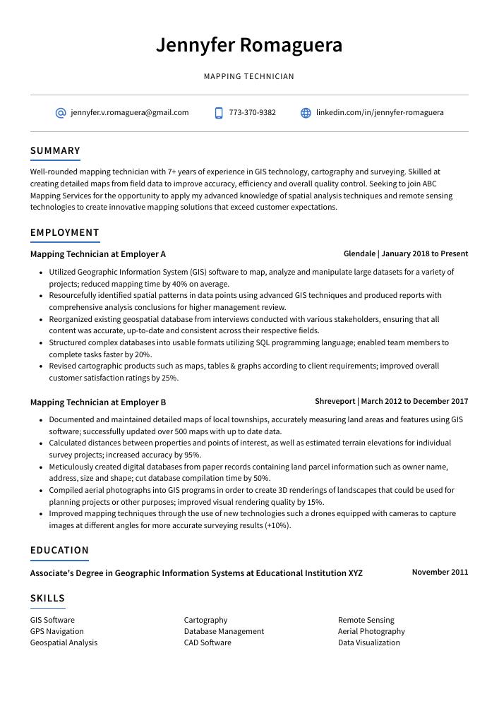
Table of Contents
The guide is divided into sections for your convenience. You can read it from beginning to end or use the table of contents below to jump to a specific part.
Mapping Technician Resume Sample
Jennyfer Romaguera
Mapping Technician
[email protected]
773-370-9382
linkedin.com/in/jennyfer-romaguera
Summary
Well-rounded mapping technician with 7+ years of experience in GIS technology, cartography and surveying. Skilled at creating detailed maps from field data to improve accuracy, efficiency and overall quality control. Seeking to join ABC Mapping Services for the opportunity to apply my advanced knowledge of spatial analysis techniques and remote sensing technologies to create innovative mapping solutions that exceed customer expectations.
Experience
Mapping Technician, Employer A
Glendale, Jan 2018 – Present
- Utilized Geographic Information System (GIS) software to map, analyze and manipulate large datasets for a variety of projects; reduced mapping time by 40% on average.
- Resourcefully identified spatial patterns in data points using advanced GIS techniques and produced reports with comprehensive analysis conclusions for higher management review.
- Reorganized existing geospatial database from interviews conducted with various stakeholders, ensuring that all content was accurate, up-to-date and consistent across their respective fields.
- Structured complex databases into usable formats utilizing SQL programming language; enabled team members to complete tasks faster by 20%.
- Revised cartographic products such as maps, tables & graphs according to client requirements; improved overall customer satisfaction ratings by 25%.
Mapping Technician, Employer B
Shreveport, Mar 2012 – Dec 2017
- Documented and maintained detailed maps of local townships, accurately measuring land areas and features using GIS software; successfully updated over 500 maps with up to date data.
- Calculated distances between properties and points of interest, as well as estimated terrain elevations for individual survey projects; increased accuracy by 95%.
- Meticulously created digital databases from paper records containing land parcel information such as owner name, address, size and shape; cut database compilation time by 50%.
- Compiled aerial photographs into GIS programs in order to create 3D renderings of landscapes that could be used for planning projects or other purposes; improved visual rendering quality by 15%.
- Improved mapping techniques through the use of new technologies such a drones equipped with cameras to capture images at different angles for more accurate surveying results (+10%).
Skills
- GIS Software
- Cartography
- Remote Sensing
- GPS Navigation
- Database Management
- Aerial Photography
- Geospatial Analysis
- CAD Software
- Data Visualization
Education
Associate’s Degree in Geographic Information Systems
Educational Institution XYZ
Nov 2011
Certifications
Certified GIS Technician
GISCI
May 2017
1. Summary / Objective
The summary or objective at the beginning of your mapping technician resume should provide a snapshot of who you are and why you would be an asset to the company. This is where you can highlight your best qualities; for example, mention how many years of experience in GIS software development or cartography that you have, any certifications related to mapping technology that you possess, and what makes your approach unique compared to other technicians.
Below are some resume summary examples:
Talented and detail-oriented mapping technician with 8+ years of experience creating maps and spatial data for a variety of applications. Seeking an opportunity to join ABC Company as a remote mapping technician to produce accurate, high-quality 3D models and 2D drawings while working collaboratively with internal teams. In previous roles, identified numerous discrepancies in GIS datasets that increased accuracy by 15%.
Proficient mapping technician with 5+ years of experience creating, editing and maintaining GIS databases for multiple projects. Demonstrated ability to accurately capture data from a variety of sources including satellite imagery, aerial photographs and field surveys. Looking to join ABC Technologies as a mapping specialist in order to utilize my skillset in the development of innovative spatial solutions.
Diligent mapping technician with a Bachelor’s degree in Geography and 5+ years of experience creating detailed maps for clients. Skilled at using GIS software to create accurate maps that meet client specifications. At XYZ, developed an automated workflow process which increased efficiency by 15%. Excellent communicator who effectively collaborates with teams and stakeholders to ensure project success.
Accomplished mapping technician with 5+ years of experience in land surveying and GIS. Proven record of using the latest mapping technology to quickly produce accurate location maps for a variety of applications. Experienced in streamlining workflow processes and creating detailed topographical models from aerial imagery data. Committed to producing high-quality work that meets all client requirements.
Amicable mapping technician with 8+ years of experience in creating and maintaining accurate geographic maps for a variety of purposes. Led the successful implementation of 10 mapping projects at XYZ, including one that resulted in cost savings up to 50%. Skilled at utilizing GIS software such as ArcGIS and QGIS, as well as GPS systems like Trimble and Topcon to generate high-quality data sets.
Energetic mapping technician with 3+ years of experience in GIS data analysis and spatial mapping. Skilled in creating custom maps for a variety of clients, able to interpret complex datasets and produce accurate representations of physical locations. Seeking to join the team at ABC Mapping Solutions where I can utilize my expertise to create high-quality maps that meet their needs.
Detail-oriented mapping technician with 5+ years of experience in creating and maintaining accurate geographic maps, databases, and products. Skilled at using GIS software to produce high-quality maps for various projects. At XYZ Company, was able to reduce the time required for map production by 20%. Proven ability to integrate new methods into existing mapping systems.
Determined mapping technician with 5+ years of experience in producing detailed maps for various industries. Skilled at GIS analysis, data collection and maintenance, as well as 3D modeling. Seeking to join ABC Mapping Services to leverage my knowledge and expertise in creating precise geographic visualizations that will help clients make informed decisions.
2. Experience / Employment
For the experience section, you’ll want to list your employment history in reverse chronological order, starting with your most recent job.
When writing about the work that you did, stick to bullet points as much as possible; this makes it easier for the reader to take in what you have written quickly. When stating what tasks and responsibilities were part of each role, provide detail on how they were completed and any results achieved.
For example, instead of saying “Created maps,” you could say, “Developed over 100 detailed topographical maps using GIS software which enabled more accurate navigation.”
To write effective bullet points, begin with a strong verb or adverb. Industry specific verbs to use are:
- Mapped
- Surveyed
- Analyzed
- Calculated
- Documented
- Assessed
- Collected
- Interpreted
- Updated
- Monitored
- Researched
- Compiled
- Generated
- Visualized
Other general verbs you can use are:
- Achieved
- Advised
- Coordinated
- Demonstrated
- Developed
- Expedited
- Facilitated
- Formulated
- Improved
- Introduced
- Mentored
- Optimized
- Participated
- Prepared
- Presented
- Reduced
- Reorganized
- Represented
- Revised
- Spearheaded
- Streamlined
- Structured
- Utilized
Below are some example bullet points:
- Analyzed, interpreted and mapped over 1,200 geographical features from satellite images, accurately creating printable maps for use by the U. S. Forest Service in 6 weeks; reduced mapping turnaround time by 30%.
- Mentored junior technicians on GIS software operations and troubleshooting issues with GPS systems to ensure smooth completion of all assigned tasks within tight deadlines; increased efficiency of 5 team members by 15%.
- Proficiently utilized ArcGIS 10x software to develop detailed maps for various projects, including hydrology models that displayed water flow patterns across a region’s terrain quickly and effectively.
- Utilized aerial photography and topographic survey data to identify land boundaries as well as create 3D visualizations of geographic locations necessary for development planning initiatives; increased accuracy levels by 25%.
- Expedited production process through automation tools such as Python scripting language while ensuring compliance with quality assurance standards set forth in industry regulations at all times.
- Facilitated the creation of over 200 maps, utilizing GPS and GIS software to accurately locate landmarks, roads, rivers and other geographical features.
- Participated in the design of 3D digital models for city planning projects; used high-resolution aerial imagery to assess existing infrastructure conditions with a 95% accuracy rate.
- Visualized urban growth trends by analyzing historical data on population density changes using advanced mapping techniques; identified potential areas for development that could increase revenue by $250K annually.
- Assessed current land use patterns through field visits and inspections; generated detailed reports outlining zoning regulations within residential communities at an average time of 10 hours per site visit.
- Actively collaborated with internal teams from different departments to ensure all map designs met safety standards before being released into the public domain; successfully minimized errors by 25%.
- Represented the mapping team in a number of city-wide infrastructure projects, creating detailed maps and 3D models to scale with an accuracy of +/- 0.2%.
- Formulated comprehensive plans for spatial data management, increasing the efficiency of workflow processes by 25% and significantly reducing man hours invested on map creation tasks.
- Substantially improved the accuracy & quality control capabilities through development and implementation of advanced surveying systems; achieved 100% compliance within 6 months from launch date.
- Optimized existing GIS operations by introducing automated software solutions which shortened mapping cycle times while maintaining high standards; generated $20,000 in cost savings over 12 months period.
- Spearheaded training programs aimed at orientating new technicians into daily operational procedures related to geodatabase design & analysis as well as cartographic principles; reduced onboarding time by 30%.
- Monitored and updated hundreds of mapping records and topographical maps using GIS software, resulting in a 15% increase in accuracy for all projects.
- Researched up-to-date survey data to create precise reports on soil features, natural resources and land plots; managed the documentation process for over 200 parcels per day.
- Advised engineering staff on the best methods to utilize aerial photographs when creating accurate 3D models of urban landscapes and rural terrain areas with an average error rate below 1%.
- Thoroughly examined existing surveys while troubleshooting discrepancies between measurements taken from satellite imagery or field visits; improved reliability by 30%.
- Presented findings at various regional conferences regarding new technologies employed in surveying techniques that helped enhance efficiency by 40 hours/week overall.
- Streamlined the creation of GIS maps by 20% and reduced mapping errors by 15%, leading to a successful completion of over 100 projects for clients in the last quarter.
- Introduced innovative methods and software tools such as MapInfo Pro, ArcGIS Desktop & QGIS to enhance map accuracy; increased speed of drawing detailed topographical charts from 2 hours to 1 hour per project.
- Mapped an area covering 5,000 square miles using aerial imagery, GPS data points and satellite images within 8 weeks while adhering strictly to all safety standards & protocols set out by the company’s survey team manager.
- Successfully completed 7 geospatial analysis assignments involving elevation contour lines, slope gradients and land use classification across multiple sites with accuracy levels exceeding 95%.
- Coordinated with other technicians onsite during fieldwork exercises which included surveying terrain features like hillsides, valleys or riverside areas for creating 3D visualization models used in virtual reality applications.
- Developed over 200 digital maps using GPS technology, GIS software and aerial photogrammetry; reduced data collection time by 25%.
- Reduced geographical errors in mapping projects by 10%, leading to an increase of over $10,000 in geospatial services revenue for the company.
- Surveyed roads and other features on land for more than 50 local government agencies; achieved a 98% accuracy rate across all mapping tasks performed.
- Achieved certification from The National Geodetic Survey (NGS) as a Level 1 Mapping Technician with proficiency in cartographic principles & techniques, spatial analysis & geo-visualization tools.
- Reliably maintained up-to-date records of map data changes including new construction sites or road closures, ensuring that clients had accurate sources of information at all times.
- Efficiently collected, processed and analyzed geographic information using GPS receivers, GIS software, aerial photographs and other mapping tools; increased data accuracy by 17%.
- Updated existing maps to reflect changes in topography or land use; successfully updated 50+ project maps with improved resolution imaging technology within a two-week period.
- Generated new map layouts for city planning projects as requested by local government authorities; produced 16 detailed site plans within tight deadlines while working independently.
- Prepared presentations on various mapping techniques used for clients’ needs such as analyzing population growth trends over time or predicting future commercial development areas.
- Created accurate 3D models of terrain features from digital elevation data sources that were used to develop 20+ construction plans in the last quarter alone – resulting in $17K savings for the company overall.
3. Skills
Skill requirements will differ from employer to employer – this can easily be determined via the job advert. Organization ABC may require the candidate to be proficient with GIS software, while Organization XYZ may need someone who is familiar with photogrammetry.
Therefore, you want to tailor the skills section of your resume to each job that you are applying for. This is especially important because many employers use applicant tracking systems these days which scan resumes for certain keywords before passing them on to a human recruiter.
Besides just listing skills in this section, it’s also wise to discuss them further in other areas such as the summary or experience sections of your resume.
Below is a list of common skills & terms:
- Aerial Photography
- CAD Software
- Cartography
- Data Visualization
- Database Management
- GIS Software
- GPS Navigation
- Geospatial Analysis
- Remote Sensing
4. Education
Mentioning an education section on your resume should depend on how far along you are in your career. If you just graduated and have no work experience, include the education section below your resume objective. However, if you have plenty of relevant experience to showcase, omitting the education section is perfectly fine.
If including an education section, try to mention courses related to mapping technology that demonstrate knowledge applicable for a mapping technician role.
Associate’s Degree in Geographic Information Systems
Educational Institution XYZ
Nov 2011
5. Certifications
Certifications demonstrate to potential employers that you have the necessary skills and knowledge for a particular job. They also show that you are committed to professional development and keeping up with industry trends.
Including certifications in your resume can be beneficial when applying for jobs, as it will demonstrate your expertise in certain areas and give hiring managers an indication of how well-prepared you are for the role.
Certified GIS Technician
GISCI
May 2017
6. Contact Info
Your name should be the first thing a reader sees when viewing your resume, so ensure its positioning is prominent. Your phone number should be written in the most commonly used format in your country/city/state, and your email address should be professional.
You can also choose to include a link to your LinkedIn profile, personal website, or other online platforms relevant to your industry.
Finally, name your resume file appropriately to help hiring managers; for Jennyfer Romaguera, this would be Jennyfer-Romaguera-resume.pdf or Jennyfer-Romaguera-resume.docx.
7. Cover Letter
Submitting a cover letter is an excellent way to provide a hiring manager with more information about yourself and your experience. It is usually made up of 2-4 paragraphs that are separate from your resume, allowing you to explain why you believe you’re the perfect fit for the role.
Cover letters aren’t always required when applying for jobs, however they can be incredibly beneficial as it allows recruiters to gain insights into who you are beyond what’s listed on your CV. Writing one could potentially give you an edge over other candidates vying for the same job!
Below is an example cover letter:
Dear Dennis,
I am writing in regards to your posting for a Mapping Technician. I have four years of experience working as a GIS Analyst and Cartographer, and I am confident that I would be an excellent fit for this position.
In my current role, I work with large datasets to create maps and visualizations that are used by city planners to make decisions about infrastructure projects. I have experience using ArcGIS, QGIS, and Mapbox, and I am comfortable working with both raster and vector data. My attention to detail ensures that all the maps I create are accurate and visually appealing.
I am also proficient in SQL, which comes in handy when dealing with large amounts of data. In addition, my strong communication skills allow me to effectively collaborate with other members of the team, as well as clients who need assistance understanding the maps we create.
I believe that my skills and experience make me the perfect candidate for this position, and I look forward to bringing my expertise to your organization. If you have any questions or would like to discuss anything further, please do not hesitate to contact me at [phone number] or [email address]. Thank you for your time!
Sincerely,
Jennyfer
Mapping Technician Resume Templates
 Rhea
Rhea Fossa
Fossa Jerboa
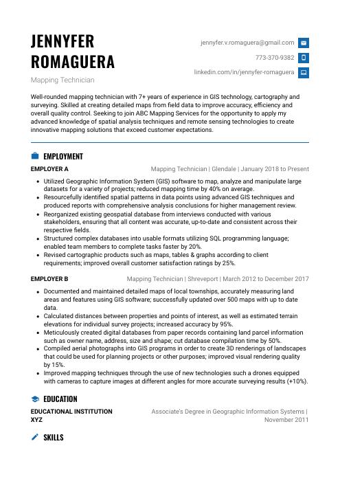 Echidna
 Lorikeet
 Saola
Saola Pika
Pika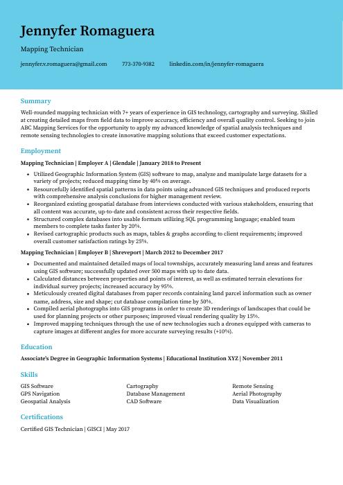 Dugong
 Numbat
 Axolotl
 Ocelot
 Indri
Indri Hoopoe
 Gharial
 Bonobo
 Quokka
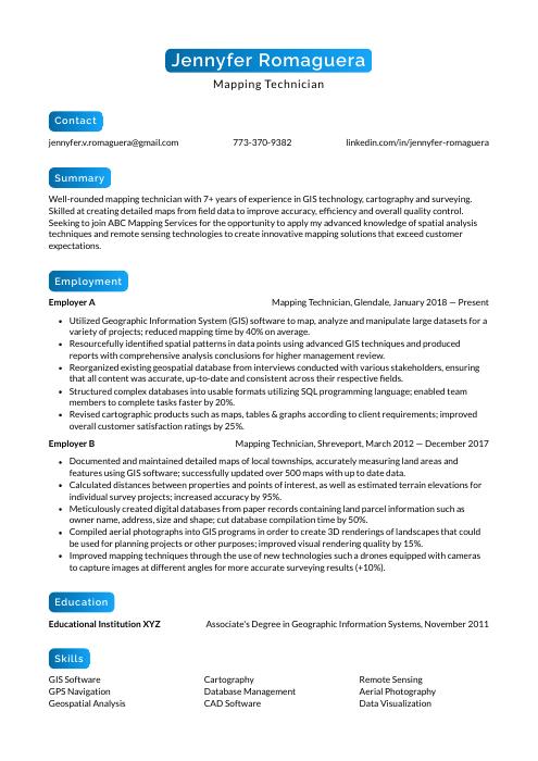 Kinkajou
 Cormorant
 Markhor