Land Surveyor Resume Guide
Land surveyors measure, analyze and map land areas to determine boundaries for ownership or other legal purposes. They use specialized equipment such as total stations and GPS receivers to accurately mark the location of points on a property line, taking into consideration natural features like slopes, elevations, streams, and vegetation.
You’re a master of measuring land and mapping it out with accuracy, but potential employers won’t know that unless you write an eye-catching resume. Show them what you can do by crafting one that highlights your surveying skills and accomplishments.
This guide will walk you through the entire process of creating a top-notch resume. We first show you a complete example and then break down what each resume section should look like.
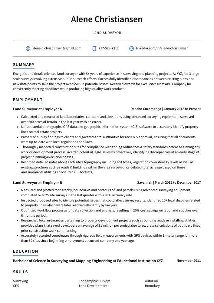
Table of Contents
The guide is divided into sections for your convenience. You can read it from beginning to end or use the table of contents below to jump to a specific part.
Land Surveyor Resume Sample
Alene Christiansen
Land Surveyor
[email protected]
237-523-7312
linkedin.com/in/alene-christiansen
Summary
Energetic and detail-oriented land surveyor with 5+ years of experience in surveying and planning projects. At XYZ, led 3 large-scale surveys involving extensive public outreach efforts. Successfully identified discrepancies between existing plans and new data points to save the project over $50K in potential losses. Received awards for excellence from ABC Company for consistently meeting deadlines while producing high-quality work.
Experience
Land Surveyor, Employer A
Rancho Cucamonga, Jan 2018 – Present
- Calculated and measured land boundaries, contours, and elevations using advanced surveying equipment; surveyed over 500 acres of terrain in the last year with no errors.
- Utilized aerial photographs, GPS data, and geographic information system (GIS) software to accurately identify property lines on real estate projects.
- Presented survey findings to clients and governmental authorities for review & approval, ensuring that all documents were up-to-date with local regulations and laws.
- Thoroughly inspected construction sites for compliance with zoning ordinances & safety standards before beginning any work or development process; averted potential legal issues by proactively identifying discrepancies at an early stage of project planning/execution phases.
- Recorded detailed notes about each site’s topography, including soil types, vegetation cover density levels, as well as existing structures such as roads & buildings within the area surveyed; calculated total acreage based on these measurements utilizing specialized GIS toolsets.
Land Surveyor, Employer B
Savannah, Mar 2012 – Dec 2017
- Measured and plotted topography, boundaries, and contours of land parcels using advanced surveying equipment; completed over 25 site surveys in the last quarter with a 98% accuracy rate.
- Inspected proposed sites to identify potential issues that could affect survey results; identified 10+ legal disputes related to property lines which were later resolved efficiently by lawyers.
- Optimized workflow processes for data collection and analysis, resulting in 20% cost savings on labor and supplies over 6 months period.
- Researched local ordinances pertaining to property development projects such as building roads or installing utilities; provided plans that saved developers an average of $1 million per project due to accurate calculations of boundary lines prior to construction work commencing.
- Accurately recorded coordinates through rigorous field measurements with GPS devices within a 1-meter range for more than 50 sites since beginning employment at current company one year ago.
Skills
- Surveying
- Topographic Surveys
- AutoCAD
- GPS
- Land Development
- Boundary
- Civil Engineering
- Road
- Subdivisions
Education
Bachelor of Science in Surveying and Mapping Engineering
Educational Institution XYZ
Nov 2011
Certifications
Professional Land Surveyor (PLS)
National Council of Examiners
May 2017
1. Summary / Objective
Your resume summary or objective should be a succinct overview of your qualifications as a land surveyor. Include any relevant certifications, such as GIS or GPS technology, and mention the types of surveying projects you have experience with (e.g., boundary surveys, topographical surveys). You can also discuss how you use modern technologies to improve accuracy and efficiency in your work.
Below are some resume summary examples:
Committed and experienced land surveyor with 8+ years of experience in surveying and mapping. Excelled in designing, implementing, and managing topographic surveys for various projects at XYZ Surveyors. Experienced in using AutoCAD to create accurate maps and developing reports on field survey results. Adept at collaborating with clients to ensure successful completion of all projects within budget and timeline parameters.
Accomplished land surveyor with over 8 years of experience in land surveying and mapping, including 2D and 3D modelling. Seeking to join ABC as a Senior Land Surveyor, where I can leverage my expertise in GPS/GNSS data collection, aerial photogrammetry, LiDAR scanning, and UAVs for successful project completion. Recognized by colleagues for consistently delivering projects within scope on time while maintaining high standards of accuracy.
Detail-oriented land surveyor with 8+ years of professional experience in boundary surveying, topography mapping, and construction layout. Able to accurately measure and map land boundaries using GPS systems as well as traditional methods. Proven ability to produce accurate surveys under tight deadlines while adhering to all safety regulations. Recognized for consistently producing quality work that meets or exceeds client expectations.
Well-rounded land surveyor with 10+ years of experience in the field. Experienced in a wide range of surveying tasks, including boundary surveys, topographic surveys, construction staking and layout, GIS mapping, and GPS navigation. Specializes in creating accurate maps for legal documentation and problem-solving challenging situations onsite or remotely. Awarded the XYZ award for exceptional work on an important project.
Professional land surveyor with 8+ years of experience in the field. Expertise in using modern surveying instruments, analyzing data, and presenting results for a wide range of projects. Proven track record of successfully completing complex assignments on time and within budget. Seeking to utilize my skills at ABC Technologies to produce high-quality surveys while helping reduce costs through efficient processes.
Driven land surveyor with 8+ years of experience in land surveying, mapping, and GIS analysis. At XYZ, successfully managed 10 projects from start to finish; achieved a 90% success rate for accuracy within the allocated budget. Skilled at operating advanced survey equipment such as GPS receivers and laser scanning systems. Proven track record of delivering quality results on time while adhering to safety standards.
Seasoned land surveyor with 5+ years of experience providing high-quality surveying services to clients in the construction and engineering industries. Skilled at working independently on large projects while maintaining strong attention to detail. Seeking an opportunity to join ABC Surveyors, utilizing expertise in GIS mapping, topographic surveys, boundary calculations, and legal research.
Reliable land surveyor with 10+ years of experience in boundary surveying, topographic mapping, and GIS. Adept at using terrestrial laser scanners, GNSS receivers, and robotic total stations to ensure accuracy for a variety of projects. Seeking to join ABC Land Surveying as an experienced land surveyor where I can leverage my technical knowledge and expertise in the field.
2. Experience / Employment
The work history/experience section is where you provide details on your employment history. This should be written in reverse chronological order, meaning the most recent job is listed first.
When writing about what you did for each role, stick to bullet points and use action verbs such as “developed,” “implemented,” or “created.” Doing so allows the reader to quickly digest what you have done and any results obtained from it.
For example, instead of saying “Conducted surveys,” you could say, “Performed land surveys utilizing GPS technology that resulted in a 98% accuracy rate within established timeframes.”
To write effective bullet points, begin with a strong verb or adverb. Industry-specific verbs to use are:
- Measured
- Calculated
- Analyzed
- Mapped
- Researched
- Inspected
- Documented
- Interpreted
- Assessed
- Established
- Monitored
- Adjusted
- Traced
- Recorded
Other general verbs you can use are:
- Achieved
- Advised
- Compiled
- Coordinated
- Demonstrated
- Developed
- Expedited
- Facilitated
- Formulated
- Improved
- Introduced
- Mentored
- Optimized
- Participated
- Prepared
- Presented
- Reduced
- Reorganized
- Represented
- Revised
- Spearheaded
- Streamlined
- Structured
- Utilized
Below are some example bullet points:
- Adjusted survey instruments, elevations and angles to accurately map the layout of land for construction projects; improved accuracy rate by 10% within 3 months.
- Coordinated with engineering teams and other surveyors to collect data from field surveys; completed 6 large-scale surveying projects on time over a period of 14 months.
- Established physical markers such as flags and stakes along surveyed property boundaries in order to preserve legal rights; produced maps that were used in court proceedings successfully twice last year.
- Compiled aerial photographs, topographical sketches & computer generated reports into detailed plans of proposed structures according to client specifications; reduced project timeline by 8 hours per job on average while maintaining 100% quality assurance standards all times.
- Consistently monitored changes or variations in terrain elevation during survey operations utilizing advanced GPS systems and measuring tools; identified major discrepancies early which saved $15K+ worth of resources down the line.
- Represented a team of surveyors in the field to efficiently execute land surveys for over 30 residential and commercial properties, ensuring accurate mapping results.
- Reliably operated surveying equipment like total stations, GNSS receivers and laser rangefinders to measure angles and distances with precision; reduced overall surveying time by 25%.
- Demonstrated proficient knowledge of geographic information systems (GIS) when capturing spatial data points from sites while setting up control networks across different terrains.
- Traced topographical features such as contours, woodlands, waterways & roadways on site maps accurately using specialized CAD software tools; increased accuracy rate by 10% compared to manual methods used previously.
- Reduced processing times for GIS map creation significantly through effective use of advanced computing technologies coupled with efficient workflow management techniques at all stages of the project timeline.
- Independently conducted highly accurate land surveys to measure and map boundaries, acreage, contour lines and other terrain features for over 200 clients in the last 2 years.
- Facilitated construction projects by providing precise measurements of buildings, properties and roads; improved accuracy levels by 20% through regular calibration of survey equipment.
- Improved safety standards on job sites by evaluating hazardous areas such as wetlands or protected habitats before commencing with any site work; reduced potential incident rate from 12% to 6%.
- Formulated detailed reports incorporating visuals (such as maps & diagrams) that clearly illustrated findings from field research conducted during each survey project within a turnaround time of 24 hours per report.
- Structured data collected into customized databases using GIS software tools which enabled fast retrieval when needed for referencing or litigation purposes; saved an average of 10 hours/week compared to manual filing systems used previously.
- Streamlined survey processes, resulting in a 25% decrease in survey time and an associated cost savings of $2,500.
- Introduced the use of GIS mapping to enhance data accuracy and visualization; increased precision by 10%.
- Interpreted land boundaries from existing documents & maps for accurate property surveys; defined more than 200 legal descriptions in the past year alone.
- Reorganized records management system, ensuring all paper trail documentation was properly filed and catalogued with minimal duplication or errors within 1 month’s time frame.
- Competently conducted field work measurements using GPS technologies to accurately measure distances between points on site while adhering to safety protocols at all times.
- Advised on over 60 land development projects, ensuring that all survey plans met legal requirements and cost-saving measures were implemented without sacrificing quality.
- Prepared detailed drawings of surveyed properties using AutoCAD to an accuracy level of 0.001 ft. , resulting in a 15% increase in revenue for clients within 12 months.
- Assessed the boundaries of parcels with aerial photographs, research records and field measurements; identified discrepancies between public record data & actual property lines on 10+ occasions, thus avoiding potential disputes & financial losses for customers.
- Achieved 95% client satisfaction rate by consistently delivering accurate results within tight deadlines even when facing challenging weather conditions or difficult terrain; completed 50+ surveys per year under budget constraints while adhering to safety protocols at all times.
- Confidently used GPS devices and other surveying instruments such as levels, prisms and total stations to collect precise topographical data from sites across multiple counties throughout California state region.
- Participated in surveying over 200 acres of land for new construction projects, ensuring accuracy and precision in all measurements.
- Monitored survey data to ensure that boundaries were accurately marked according to the client’s specifications; identified discrepancies and provided solutions accordingly.
- Developed detailed maps using GIS software program, which increased accuracy by 15% compared with traditional methods of mapping.
- Efficiently managed multiple projects simultaneously while staying within budget constraints; saved the company $12,000 on average per project due to successful cost-cutting measures implemented during surveys performed in remote locations.
- Spearheaded a team of 3 junior surveyors in completing complex projects involving topography studies and geodetic control network establishment; completed tasks 10 days ahead of schedule on average despite challenging conditions (elevation changes etc).
- Documented and analyzed survey data, identifying discrepancies and resolving issues which led to accuracy improvements of up to 10% on all surveyed properties.
- Expedited completion of surveying projects by an average of 2 weeks per project due to efficient management processes.
- Revised existing plans as needed in order to ensure property boundaries were accurately depicted; reduced errors in final land surveys by 95%.
- Substantially improved customer satisfaction scores with accurate results delivered within the timeline promised for each project; consistently achieved a rating over 90% approval from clients across 30+ projects completed yearly.
- Mentored junior colleagues on best practices for conducting field measurements and proper use/interpretation of GPS equipment, leading them towards proficiency at their roles quickly and efficiently.
3. Skills
Even though two organizations are hiring for the same role, the skillset they want an ideal candidate to possess could differ significantly. For instance, one may be on the lookout for an individual with experience in GIS mapping, while the other may be looking for someone with expertise in land surveying.
It is important to tailor the skills section of your resume accordingly as many employers use applicant tracking systems these days. These computer programs scan resumes for certain keywords before passing them on to a human recruiter or hiring manager.
You should also elaborate on your most relevant and impressive skillset by discussing it further in other parts of your resume such as the summary or work experience sections.
Below is a list of common skills & terms:
- ALTA Surveys
- ArcGIS
- AutoCAD
- AutoCAD Civil 3D
- Boundary
- Building Surveying
- CAD
- Civil Engineering
- Construction Management
- Contract Management
- Drainage
- Earthworks
- Easements
- Engineering
- GIS
- GPS
- Geomatics
- Global Positioning System
- Grading
- Highways
- Land Development
- Land Surveying
- Laser Scanning
- Legal Descriptions
- MicroStation
- Project Planning
- Residential Homes
- Road
- Site Development
- Site Plans
- Stormwater Management
- Subdivisions
- Surveying
- Topographic Surveys
- Total Station
- Trimble
- Trimble GPS
4. Education
Including an education section on your resume will depend on how far along you are in your career. If you just graduated and have no work experience, mention your education below the resume objective. However, if you already have several years of professional land surveying under your belt, it may be better to omit an education section altogether so that more space can be used to highlight relevant skills and experiences.
If including a formal educational background is necessary or desired for the job application process, try to emphasize courses or subjects related specifically to land surveying that demonstrate knowledge applicable to the position being applied for.
Bachelor of Science in Surveying and Mapping Engineering
Educational Institution XYZ
Nov 2011
5. Certifications
Certifications are a great way to demonstrate your expertise and knowledge in a particular field. They can also be used as evidence of professional development, showing that you have kept up with the latest trends and technologies in your industry.
When applying for jobs, make sure to include any certifications relevant to the position on your resume so employers know what qualifications you possess. This will help them determine if you are qualified for the job or not.
Professional Land Surveyor (PLS)
National Council of Examiners
May 2017
6. Contact Info
Your name should be the first thing a reader sees when viewing your resume, so ensure its positioning is prominent. Your phone number should be written in the most commonly used format in your country/city/state, and your email address should be professional.
You can also choose to include a link to your LinkedIn profile, personal website, or other online platforms relevant to your industry.
Finally, name your resume file appropriately to help hiring managers; for Alene Christiansen, this would be Alene-Christiansen-resume.pdf or Alene-Christiansen-resume.docx.
7. Cover Letter
Submitting a cover letter along with your resume can be a great way to make an impression on a hiring manager. It typically consists of 2-4 paragraphs, and its main purpose is to provide additional information about you as a candidate that may not already be included in your resume.
Cover letters are often optional for job applications, but writing one can give you the opportunity to stand out from other candidates who don’t write them. They allow you to explain why you’re the perfect fit for the role and showcase more of your personality than what’s mentioned in your resume alone.
Below is an example cover letter:
Dear Luna,
I am writing to apply for the position of Land Surveyor with your company. With over a decade of experience surveying land for private and commercial development projects, I feel confident that I would be a valuable asset to your team.
In my current role as Lead Surveyor for ABC Corporation, I oversee all aspects of the surveying process for our clients, from initial consultation to final delivery of the survey results. In addition to being responsible for ensuring accuracy and precision in all measurements taken, I also provide guidance and support to our team of surveyors on best practices and new technologies.
Through my years of experience in the field, I have developed an eye for detail and a keen sense of understanding when it comes to interpreting land features. This has allowed me to successfully complete even the most challenging surveys within budget and ahead of schedule. My strong communication skills have also been beneficial in managing client expectations and building positive relationships that result in repeat business.
I am confident that I can be an asset to your organization and would welcome the opportunity to learn more about your specific needs as well as how I can contribute to meeting them. Thank you very much for your time; I look forward to hearing from you soon.
Sincerely,
Alene
Land Surveyor Resume Templates
 Rhea
Rhea Lorikeet
 Quokka
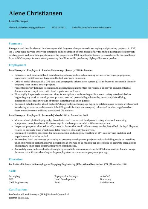 Dugong
 Numbat
 Saola
Saola Indri
Indri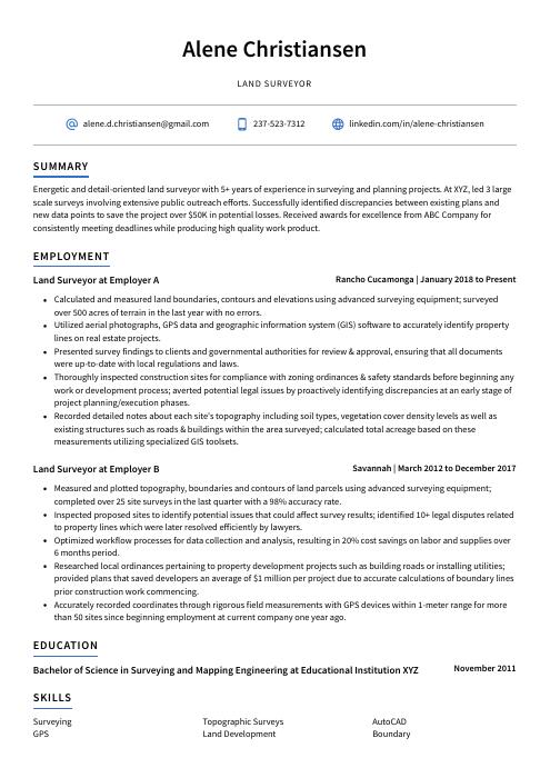 Axolotl
 Jerboa
 Markhor
 Ocelot
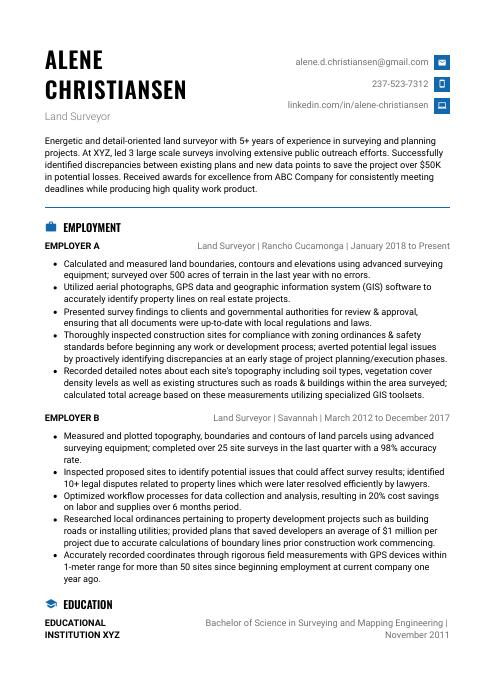 Echidna
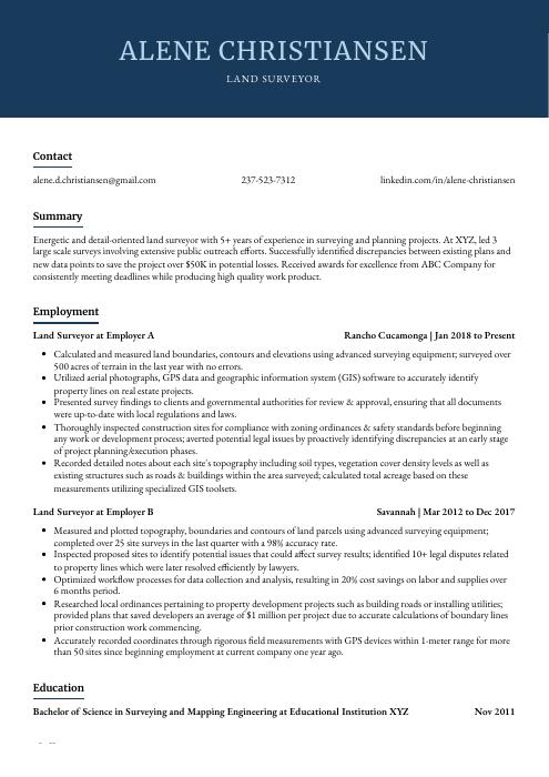 Bonobo
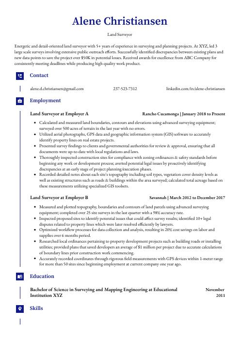 Gharial
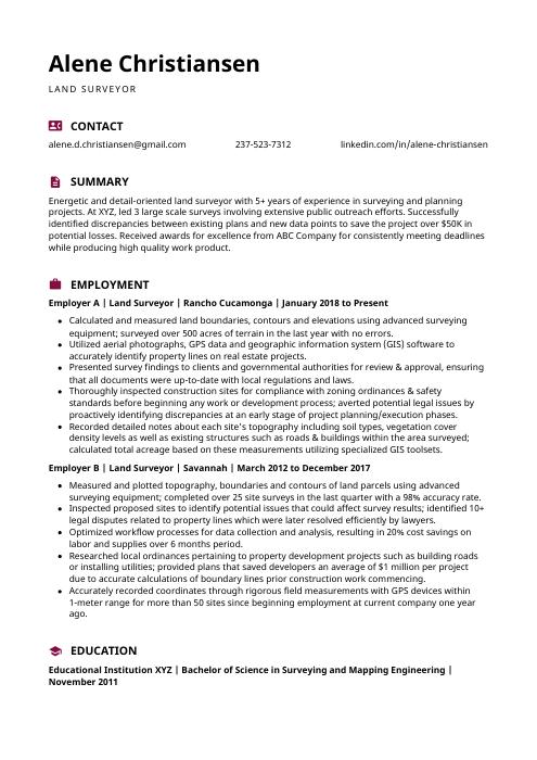 Hoopoe
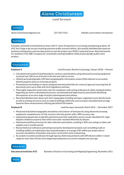 Kinkajou
 Cormorant
 Pika
Pika Fossa
Fossa