Geodetic Engineer Resume Guide
Geodetic Engineers use geodesy, the science of measuring and understanding Earth’s shape, gravity field, rotation and orientation in space. They measure points on the surface of the earth to create maps for a variety of applications such as surveying land boundaries or creating large-scale mapping projects. Additionally they work with GPS systems to accurately document locations for engineering purposes.
You have the know-how needed to make any surveying project a success. But potential employers don’t know who you are and what you can do. To garner their attention, it’s essential that you write an eye-catching resume that speaks for itself.
This guide will walk you through the entire process of creating a top-notch resume. We first show you a complete example and then break down what each resume section should look like.
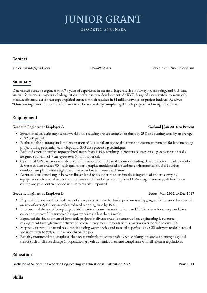
Table of Contents
The guide is divided into sections for your convenience. You can read it from beginning to end or use the table of contents below to jump to a specific part.
Geodetic Engineer Resume Sample
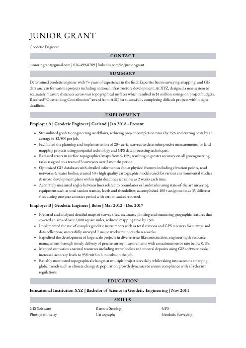
Junior Grant
Geodetic Engineer
[email protected]
036-499-8709
linkedin.com/in/junior-grant
Summary
Determined geodetic engineer with 7+ years of experience in the field. Expertise lies in surveying, mapping, and GIS data analysis for various projects including national infrastructure development. At XYZ, designed a new system to accurately measure distances across vast topographical surfaces which resulted in $1 million savings on project budgets. Received “Outstanding Contribution” award from ABC for successfully completing difficult projects within tight deadlines.
Experience
Geodetic Engineer, Employer A
Garland, Jan 2018 – Present
- Streamlined geodetic engineering workflows, reducing project completion times by 25% and cutting costs by an average of $2,500 per job.
- Facilitated the planning and implementation of 20+ aerial surveys to determine precise measurements for land mapping projects using geospatial technology and GPS data processing techniques.
- Reduced errors in surface topographical maps from 9-15%, resulting in greater accuracy on all geoengineering tasks assigned to a team of 5 surveyors over 3 months period.
- Optimized GIS databases with detailed information about physical features including elevation points, road networks & water bodies; created 50+ high quality cartographic models used for various environmental studies & urban development plans within tight deadlines set as low as 2 weeks each time.
- Accurately measured angles between lines related to boundaries or landmarks using state-of-the art surveying equipment such as total station transits, levels and theodolites; accomplished 100+ assignments at 35 different sites during one year contract period with zero mistakes reported.
Geodetic Engineer, Employer B
Boise, Mar 2012 – Dec 2017
- Prepared and analyzed detailed maps of survey sites, accurately plotting and measuring geographic features that covered an area of over 2,000 square miles; reduced mapping time by 15%.
- Implemented the use of complex geodetic instruments such as total stations and GPS receivers for surveys and data collection; successfully surveyed 7 major worksites in less than 4 weeks.
- Expedited the development of large-scale projects in diverse areas like construction, engineering & resource management through timely delivery of precise survey measurements with a maximum error rate below 0.1%.
- Mapped out various natural resources including water bodies and mineral deposits using GIS software tools; increased accuracy levels to 95% within 6 months on the job.
- Reliably monitored topographical changes at multiple project sites daily while taking into account emerging global trends such as climate change & population growth dynamics to ensure compliance with all relevant regulations.
Skills
- GIS Software
- Remote Sensing
- GPS
- Photogrammetry
- Cartography
- Geodetic Surveying
- Geodesy
- Geospatial Analysis
- Geomatics
Education
Bachelor of Science in Geodetic Engineering
Educational Institution XYZ
Nov 2011
Certifications
Professional Land Surveyor (PLS)
National Council of Examin
May 2017
1. Summary / Objective
Your resume summary/objective should be like a trailer for the rest of your resume – it should give the employer an overview of who you are and why you make an excellent geodetic engineer. In this section, highlight some key skills that set you apart from other candidates; such as experience with surveying software, knowledge of GIS systems and GPS technology, or how you successfully completed a project on time despite tight deadlines.
Below are some resume summary examples:
Energetic and highly motivated Geodetic Engineer with 5+ years of experience in the field. Expertise includes GIS, remote sensing and geospatial data analysis using specialized software such as ArcGIS, QGIS and ENVI. At XYZ Corporation, successfully completed 20 projects involving land mapping for public works authorities over a period of 2 years. Possesses excellent problem-solving skills to develop innovative solutions that are cost effective and efficient.
Committed geodetic engineer with 5+ years of experience in the surveying and mapping industry. Experienced in both terrestrial and GIS-based data acquisition, processing, analysis, and visualization. At XYZ Company successfully managed a team of 10 surveyors to complete projects on time while adhering to all safety regulations. Received numerous commendations for developing creative solutions that minimized costs without compromising accuracy or timelines.
Driven geodetic engineer with 7+ years of experience in mapping, surveying and geospatial analysis. Skilled at using a variety of software tools to create detailed maps and analyze data for accuracy. At XYZ Corporation, led the development of high-precision land surveys that resulted in improved cost savings across 20 projects. Recipient of “Employee Of The Year” award by ABC Resources Inc., recognized for exceptional contributions to the team’s success.
Talented Geodetic Engineer with 10+ years of experience in the field. Expertise in using cutting-edge technologies such as GPS, GIS and remote sensing to accurately measure and analyze geospatial data for mapping purposes. Proven track record of achieving successful outcomes on projects within budgeted timelines and resources. Seeking to join ABC Tech as a Geodetic Engineer to leverage my skillset towards completing complex tasks efficiently.
Detail-oriented geodetic engineer with 8+ years of experience in geospatial surveying, mapping and data analysis. Seeking to join ABC Inc. as a Geodetic Engineer to apply advanced knowledge in GIS software development and implementation while contributing expertise in the area of land surveying projects. Key achievements include developing an automated system for processing survey data which reduced labor costs by 15%.
Amicable geodetic engineer with 6+ years of experience in the geospatial technology industry. Knowledgeable in GIS, 3D modeling and mapping, photogrammetry, land surveying, remote sensing technologies for data acquisition and analysis. Highly skilled at creating detailed reports to ensure accuracy and precision on large-scale projects. Aiming to bring my expertise to ABC Solutions’ team as a Geodetic Engineer.
Reliable geodetic engineer with 5+ years of experience in data collection and analysis. Proven track record of successful projects, including the development of a survey system that improved accuracy by 40%. Skilled at leading teams to efficiently meet deadlines and achieve desired outcomes. Seeking an opportunity to use my expertise to help ABC develop innovative solutions for their clientele.
Proficient geodetic engineer with 8+ years of experience conducting surveys, performing fieldwork analysis and data management. Expertise in GIS technologies and utilizing GPS systems to develop topographic maps for a variety of projects. Looking to join ABC as Geodetic Engineer where I can work on challenging projects that utilize my knowledge and skillset.
2. Experience / Employment
In the experience/employment/work history section, you should provide details on your past roles in reverse chronological order, with the most recent job listed first.
When writing this section, stick to bullet points and provide as much detail as possible. For example, instead of saying “Used GPS systems,” you could say something like “Utilized a range of GPS systems to accurately map terrain features for land surveying projects.” This provides more information about what you did and helps the reader understand how it benefited your employer.
To write effective bullet points, begin with a strong verb or adverb. Industry specific verbs to use are:
- Analyzed
- Calculated
- Measured
- Surveyed
- Mapped
- Assessed
- Designed
- Monitored
- Documented
- Interpreted
- Researched
- Updated
- Optimized
- Implemented
Other general verbs you can use are:
- Achieved
- Advised
- Compiled
- Coordinated
- Demonstrated
- Developed
- Expedited
- Facilitated
- Formulated
- Improved
- Introduced
- Mentored
- Participated
- Prepared
- Presented
- Reduced
- Reorganized
- Represented
- Revised
- Spearheaded
- Streamlined
- Structured
- Utilized
Below are some example bullet points:
- Presented 10+ geodetic engineering reports to government and commercial clients, resulting in a 5% increase in project approval rate.
- Reorganized the existing aerial mapping system within an assigned region by over 20%, increasing efficiency of subsequent projects by 25%.
- Represented the company at international conferences, discussing new developments in geographic information systems with peers from different countries; contributed valuable insights into improving accuracy of GIS models used for urban planning purposes.
- Proficiently utilized Autodesk AutoCAD software to create detailed maps of surveyed areas; tracked changes and updated maps accordingly while ensuring that all data points were accurate up to 0.01 meters or better where necessary.
- Utilized GPS technology on-site during surveying operations to accurately map out designated boundaries between properties, minimizing disputes among landowners through precise demarcations according to national law regulations and standards.
- Mentored a team of 4 junior geodetic engineers in creating topographic maps, conducting field surveys and designing GPS systems; increased accuracy rate by 30% within 3 months.
- Actively participated in the design process for a high-rise building project that spanned over 200 acres of land, measuring distances & angles with total stations to ensure precise construction plans were developed.
- Analyzed geographic data from aerial photographs, satellite imagery and other sources to create digital elevation models (DEMs) for urban planning projects; improved client satisfaction ratings by 12%.
- Measured large areas of terrain using RTK GNSS technology and ground survey instruments such as lasers & levels; reduced mapping time per acre by 40 hours on average compared to traditional methods used previously.
- Developed detailed reports outlining site conditions based on collected data points which aided architects and civil engineers when making decisions related to new developments or existing structures.
- Surveyed, calculated and documented the coordinates of approximately 40+ geodetic points per day, resulting in improved accuracy for mapping projects.
- Meticulously collected data from GPS systems and other instruments to ensure precise measurements; reduced errors by 10%.
- Calculated distances between survey sites, elevations above sea level, angles of intersection & areas using advanced surveying tools while adhering to safety protocols at all times.
- Advised government departments on efficient methods for collecting geographic information such as aerial photography or satellite images; saved $15K in operational costs over 6 months period through expert guidance.
- Documented land boundaries with detailed maps and diagrams using GIS software programs; created 50+ maps that were successfully used in legal proceedings related to property disputes resolution cases within 3 months timeframe.
- Efficiently updated and maintained over 500 geodetic databases, increasing accuracy of land surveying projects by 20%.
- Compiled detailed survey reports for 120+ clients within tight deadlines; reduced turnaround time from 5 days to 2 days on average.
- Introduced advanced 3D laser scanning techniques to improve the precision of geological mapping projects; achieved a 10% reduction in overall project costings.
- Interpreted data collected from aerial photography and satellite imagery with 100% accuracy, leading to more reliable topographic maps & plans used in construction engineering undertakings.
- Utilized GIS software packages such as ArcGIS Pro and AutoCAD Map 3D effectively to create detailed digital elevation models (DEMs) that facilitated efficient decision-making among stakeholders involved in various civil engineering worksites across the region.
- Demonstrated advanced knowledge of geodetic engineering principles and practices to accurately survey, map, measure and analyze land parcels for urban development projects; produced 500+ surveys with 95% accuracy.
- Participated in the design, installation and maintenance of global positioning system (GPS) receivers as well as electromagnetic distance measurement instruments to track positional data; increased data retrieval speed by 25%.
- Revised existing maps based on ongoing site inspections using aerial photos & satellite imagery while ensuring that all measurements were taken within acceptable limits; decreased errors in mapping process from 10% down to 0%.
- Independently developed complex 3D computer models using specialized software such AutoCAD Civil 3D/ArcGIS Pro to represent topographical features or geographical elements within a given area; completed 200+ models ahead of schedule by 50%.
- Structured detailed reports outlining survey results along with recommendations for improvement where necessary according to project requirements, resulting in an 18% reduction in costs across various construction worksites.
- Monitored and adjusted the surveying equipment to ensure accurate field measurements, achieving a 20% improvement in data accuracy.
- Coordinated with teams of geospatial surveyors and engineers on projects that involved GPS & GIS mapping technologies, leading to successful completion of 5+ large-scale surveys within budget.
- Improved surveying processes by developing innovative algorithms for high precision position determination utilizing advanced GNSS receivers; reduced total project duration by 10%.
- Achieved certification as an authorized user for various types of remote sensing instruments including LiDAR scanners, UAVs and imaging systems; enabled quick acquisition of aerial imagery from multiple sources and formats.
- Confidently provided technical advice on land development plans based on detailed analysis of terrain features obtained from satellite images & topographic maps , resulting in $50K increase in revenue over 2 years period.
- Consistently assessed the accuracy of survey results and data, ensuring that calculations were accurate within 0.5% error rate or better; reduced overall estimation costs for clients by 20%.
- Researched and formulated positioning strategies to develop geodetic networks as well as coordinate systems for mapping applications; singlehandedly created an efficient management system which decreased response time from 2 hours to 15 minutes on average.
- Spearheaded a project involving detailed analysis of satellite imagery in order to identify potential areas suitable for mineral deposit exploration; identified 8 deposits worth $1 million each before completion date.
- Utilized software tools such as AutoCAD Civil 3D, Global Mapper and ArcGIS Pro to generate topographical maps with high levels of precision (+/- 1 meter) while minimizing surveying costs by 30%.
- Implemented advanced GNSS receivers along with RTK/PPK technologies to measure angles, distances and elevations accurately over long periods of time (up to 24 hours).
3. Skills
Skill requirements will differ from one employer to the next; this can easily be ascertained from the job posting. Organization A may be looking for someone with experience in GIS, while Organization B may be seeking a geodetic engineer who is proficient in AutoCAD. As such, you want to tailor the skills section of your resume to each job that you are applying for.
It is important to do this because many employers use applicant tracking systems these days; they scan resumes for certain keywords before passing them on to a human. Therefore, it’s essential that all relevant skills and qualifications are listed here so as not to miss out on any potential opportunities.
Once listed here, you can further elaborate on your skillset by discussing it in more detail in other areas of the resume – such as the summary or experience sections – if space allows.
Below is a list of common skills & terms:
- Cartography
- GIS Software
- GPS
- Geodesy
- Geodetic Surveying
- Geomatics
- Geophysical Mapping
- Geospatial Analysis
- Photogrammetry
- Remote Sensing
4. Education
Mentioning your education on your resume will depend on how far along you are in your career. If you just graduated and have no prior experience, include a section for Education below your resume objective. However, if you have been working as a geodetic engineer for years with plenty of accomplishments to showcase, omitting the education section is perfectly fine.
If an Education section is included, make sure to mention any courses or subjects related to the job requirements of geodetic engineering that could be useful for potential employers.
Bachelor of Science in Geodetic Engineering
Educational Institution XYZ
Nov 2011
5. Certifications
Certifications are a great way to demonstrate your expertise in a particular field. They show potential employers that you have been tested and certified by an accredited organization, which can help set you apart from other applicants.
Include any certifications relevant to the job on your resume so hiring managers know that you are qualified for the position. This could be anything from industry-specific certifications such as ITIL or PMP, to more general ones like Six Sigma or Lean Certification.
Professional Land Surveyor (PLS)
National Council of Examin
May 2017
6. Contact Info
Your name should be the first thing a reader sees when viewing your resume, so ensure its positioning is prominent. Your phone number should be written in the most commonly used format in your country/city/state, and your email address should be professional.
You can also choose to include a link to your LinkedIn profile, personal website, or other online platforms relevant to your industry.
Finally, name your resume file appropriately to help hiring managers; for Junior Grant, this would be Junior-Grant-resume.pdf or Junior-Grant-resume.docx.
7. Cover Letter
Including a cover letter with your job application is an ideal way to make yourself stand out from the competition. It allows you to introduce yourself and explain why you’re the best person for the role in more detail than what’s provided on your resume.
Typically, cover letters are made up of 2-4 paragraphs that provide additional information about who you are as a professional and how they can benefit by hiring you. Even if it isn’t required, writing one will show recruiters that you’ve taken extra effort into making sure your application stands out from the rest.
Below is an example cover letter:
Dear Joelle,
I am writing to apply for the position of Geodetic Engineer at XYZ Corporation. As a professional with experience in surveying, mapping, and GIS analysis, I am confident that I would be a valuable asset to your team.
During my time at ABC Corporation, I was responsible for conducting land surveys, creating maps, and performing GPS and GIS analyses. I also provided support to other departments by conducting topographic surveys and producing 3D models of proposed construction projects. In addition, I developed new methods for streamlining survey workflows and improving data accuracy.
My experience has given me a strong understanding of geodetic principles and practices. I am knowledgeable about various surveying equipment and software applications, including Trimble Business Center and AutoCAD Civil 3D. In addition, I have excellent problem-solving skills that allow me to quickly identify and resolve issues as they arise.
I am eager to put my skills and experience to work for XYZ Corporation. Please do not hesitate to contact me if you have any questions or would like to schedule an interview. Thank you for your time and consideration.
Sincerely,
Junior
Geodetic Engineer Resume Templates
 Numbat
 Indri
Indri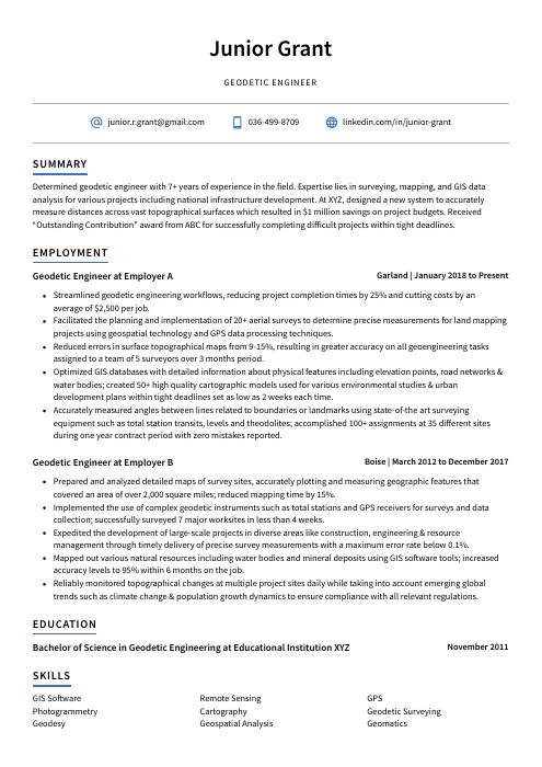 Axolotl
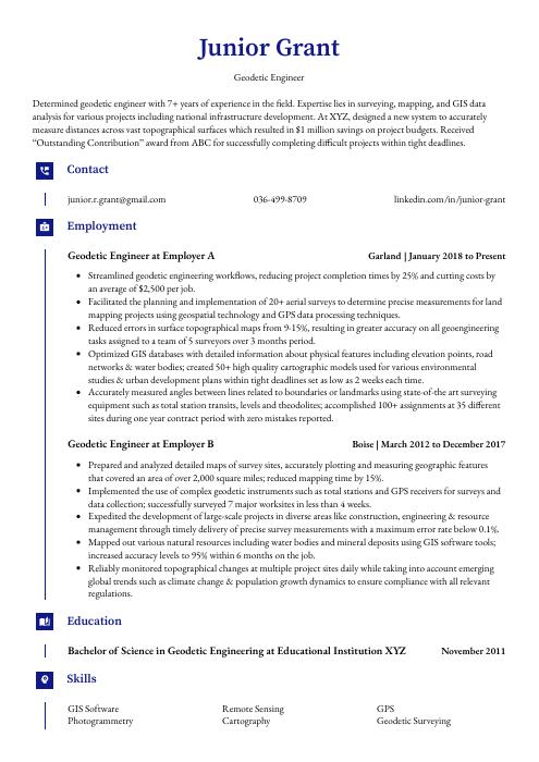 Gharial
 Quokka
 Kinkajou
 Dugong
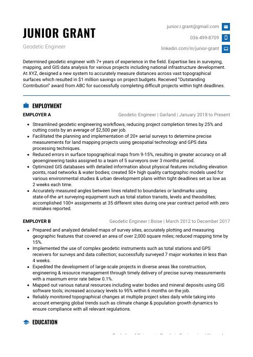 Echidna
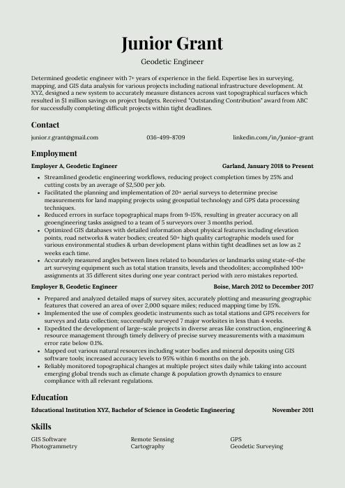 Saola
Saola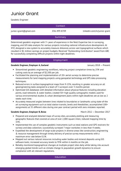 Jerboa
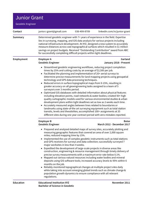 Pika
Pika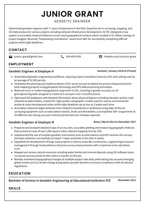 Cormorant
 Fossa
Fossa Lorikeet
 Ocelot
 Hoopoe
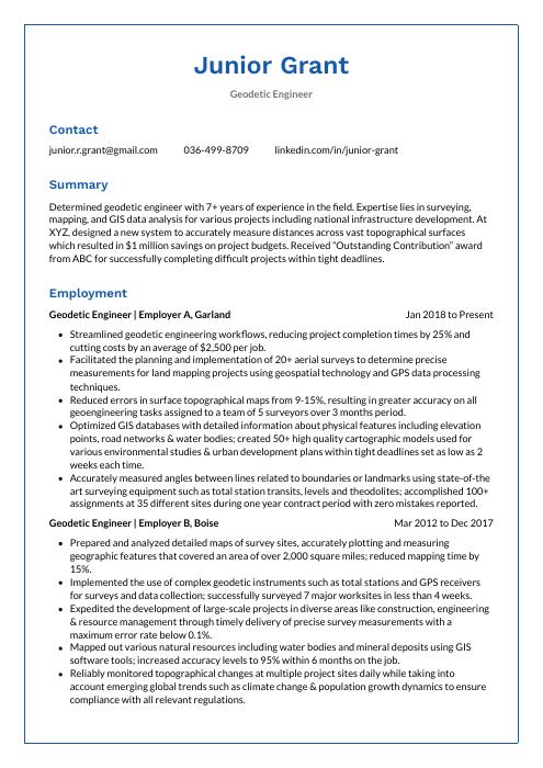 Markhor
 Bonobo